
Beresan, Cherson, South Russia Map
South Russian-German Colonies of our Forefathers.

 ROLL Reunion
[
TRANSLATE:


 |
Current Map |
1800's Beresan Map
]
|
Current Map |
1800's Beresan Map
]
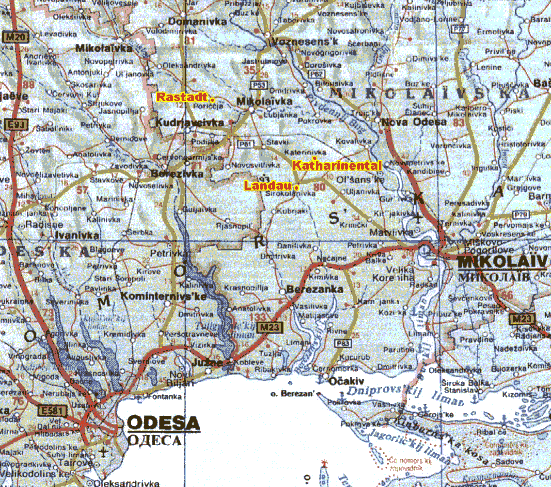 CURRENT MAP of BERESAN, CHERSON, SOUTH RUSSIA (now know as the UKRAINIAN states of ODESKA and MIKOLAIVS'KA)
 Beresan District on-line map
Larry Spiry writes,
"Russian Administration
Today, the land of our German-Russian ancestors, is called 'Ukraine', a nation that gained its independence during the breakup of the
Communist Soviet Union. Before that, it was one of the fifteen Socialist
Soviet Republics forming the USSR. And before that, it was the land that we
commonly referred to as South Russia, or New Russia. The government
administrations in this area have changed rather drastically over the years,
from monarchy type appointed governments, to military administrations, to
socialist communism, and finally to a free republic. Today the Ukraine
nation consists of governmental districts similar to our American States and these
are called 'oblasts.' Several of these Ukrainian oblasts are the roots of
many of our German-Russian ancestors. These are the oblasts of Odessa,
Nikolayev, Kherson and Crimea. The adjacent independent
country of Moldova is also an area of our roots and within its boundaries is
contained a German-Russian district called Bessarabia. Bessarabia lies just
to the west of the Odessa Oblast. In the early days, 'oblasts' were called
'provinces,' and it is these provinces that are addressing when we
discuss the administration of the German-Russian Colonies.
Ukraine today has a population approaching 60 million people. The size of
this country is slightly larger than the landmass of North and South Dakota,
and Minnesota combined. It is hard to imagine that this land was very
sparsely populated in the late 1700's. But with the influx of immigrants
from central Europe, this land soon became a central point for European
grain farmers. This land was becoming more and more productive in spite of
the many various plagues that hit these Russian communities.
The administration of these new communities in South Russia was critical for
the economical development of the land. Provinces emerged to provide better
government direction for the settlers. The capital of each province is
usually the town that bears the same name, for example, Odessa of the Odessa
Province, Nikolayev of the Nikolayev Province, and Kherson (also spelled as
Cherson) of the Kherson Province.
I have found that the author Konrad Keller gives the most information on the
governments that ruled our ancestors. He writes that up until 1774, the
military ruled this region of newly conquered land from the Turks. These
possessions had relatively few people and what they did have were fiercely
independent, the Cossacks, the Tartars and the roaming Kurd tribes. In the
treaty that was finally signed in 1774, the Russians gained from the Turks,
free access to the Black Sea for the shipping of their goods. In return, the
Turks were given portions of their land back. Free shipping on the Black Sea
was vital to the Russian economy at that time. No doubt, the Russian
presence was not really welcomed by the Turkish government, but remember,
the Turks lost the war.
The South Russian government that was established in 1774 included portions
of the upper Cherson province and to the right of that, an area referred to
as Jekaterinoslav Province. Nine years later, in 1783, the governorship of
Jekaterinoslav was officially created. On today's map, Jekaterinoslav is
not shown, but its capital would have been where Dnepropetrovsk, a city of
one and a quarter million, is located today. The city of Cherson was
founded in 1779. Nikolayev became a city in 1789 and finally Odessa was
founded in 1794.
In 1795, the governorship of Vosnesensk was created which brought all of
these provincial district capitals together, Vosnesensk, Cherson,
Elizabethgrad, Tiraspol, Odessa, Nikolayev, to name a few. One year later,
these provinces were placed under the New Russian General Government. It
was in 1803 that the Nikolayev government was renamed the Cherson
government. The first Governor-General of this entire region actually lived
in Jekaterinoslav first, until 1805, when he moved to Odessa. Bessarabia,
incidentally was brought into the fold in 1812. All of these regions,
including Bessarabia, were called South Russia. Much of Bessarabia lies in
the country of Moldova today. The Cherson Province, then, consisted of
three principle areas, Odessa on the left, Nikolayev in the center and its
own district, Cherson on the right.
Keller mentions that these districts had governorships and counties. The
county reference must be the various 'districts' that contained the
villages. For example Glueckstal, Beresan and Liebenthal Districts, to name
a few, would be considered as counties. He also refers to Cherson as having
2 governorships and 6 counties, and he states that this was the way it was
at 'present.' I believe he was writing this data in the year of 1904 and
1905.
The Czar was always the highest level of authority for the German settlers,
up until the time the communists wrested the power in Russia. At first,
when Catherine was in power, a Guardianship Council was created to help with
the administration of these new settlers. The Council was disbanded in
1782, and this had a pronounced adverse affect on the colonies. The Council
tasks were taken over by the governorships of the provinces, who did not
deal properly with the immigrant colonies. Consequently, Keller writes that
the colonies went into a series of decay years. Fifteen years later, in
1797, Russia reinitiated a form of the Guardian Council at Saratov, which is
up around the Volga River region in Russia. Three years later, another
office was set up in Jekaterinoslav, which was a great deal closer for the
New Russia immigrants. Soon this office too would become over loaded, and
finally, in 1818, a Welfare Committee was established for the immigrant
colonies in the provinces of Cherson, Tauria, Jekaterinoslav and Bessarabia.
This authority too became overworked and had to expand to meet the
increasing needs and demands of the immigrants. The Welfare Committee
remained in affect until 1871 when it was disbanded due to the
"Russification" efforts of the government, that is, the immigrants had no
more special rights. They now were classified as Russians, like everyone
else within the country.
During the reign of Czar Paul I, the right for each village to self-govern
was initiated in 1800. A village mayor, two aldermen and a representative
for each 10 families were elected. The village administration also had a
village secretary, who was appointed by the Welfare Committee.
In addition to the village governments, colonies were grouped together to
form 'volosts,' or districts, which had a government one level up from the
village authorities. The district government elected a chief mayor, two
assessors, and a number of assemblymen representing the villages. This
group also had a secretary that was appointed by the Welfare Committee.
Incidentally, the village mayors all reported to the district mayor.
Policies established at the district level were funneled down to the village
leaders for implementation. Conversely, those problems, which could not be
resolved at a lower level, were submitted to the 'district' for resolution.
It is interesting to note that in accordance with Author Konrad Keller, 'N.
Spiry' was listed as a village secretary in 1819. He later became the
Beresan District secretary from 1821 to 1823. This information seems to
authenticate the Spiry family story handed down through the generations,
which speaks of our 'senior' Spiry as being hired by the Russians as a
surveyor. By the way, other names for the secretary position were recorder,
clerk and 'schreiber' a German term for 'writer,' or 'recorder.' This was a
prestigious job and the secretary was appointed, not elected as the others.
The secretary was sort of a workhorse for the administration and surveying
would definitely be one of his jobs."

Source - Britannnica:
The province of Kherson dates from 1803. It is part of the
Ukraine. Kherson, an oblast (state) in the Ukrainian Soviet Socialist Republic of the
U.S.S.R., was formed in 1944 and covers an area of 10,463 square miles. It lies
across the lower Dnieper River and along the shores of the Black sea, Sivash and
the Sea of Azov. It comprises a level plain of Tertiary rocks with almost no
surface water apart from the Dnieper and with extensive sands, often forming
bare dunes. The Askania-Nova Nature reserve [part of one of the estates of
the German-Russian Falz-Fein family}, used for scientific research, is
located in southern Kherson. The climate is dry, with only 12-14 inhes of
rain a year, and although much of the oblast is under plow to wheat, maize
(corn) and sunflowers, agriculture suffers severely from drought. The
population, the least dense in the Ukraine, numbered 824,167 (1959 Census),
of whom 333,119 (40%) were urban and 491,048 rural.
Kherson, a town and seaport and the administrative centre of Kherson oblast
stands on the right bank of the lower Dnieper, 15.5 miles from its mouth.
Pop. (1959) 157,995. It was founded by G. A. Potemkin in 1778 as a fortress
to protect the newly acquired Black Sea frontage of Russia. Its name was
derived from the supposition that it was on the site of the ancient Greek
colony Tauric, or Heracleotic, Cheronese (more probably Sevastopol. In 1803
it became the seat of a government (province). Its importance as a port
dates only from 1901, when the Revach, a distributry of the Dnieper, was
dredged, but the cascade of barges on the Dneiper built in Soviet times has
greatly increased trade, especially in petroleum from the Caucusus area. The
navigation season lasts from early March to late December.

1800's BERESAN DISTRICT, SOUTH RUSSIA MAP (now know as the UKRAINIAN states of ODESKA [the eastern tip] and MIKOLAIVS'KA [the southwestern side])
Beresan Map - Detailed Explanation
Note: these valleys are only rough estimates and may be much shorter/longer or wider/narrower than they appear on the map