
Southwest North Dakota Maps

 ROLL Reunion
[
TRANSLATE:


 ]
]
Other NORTH DAKOTA Maps 
North Dakota Towns of our Forefathers.
 1976 Terraserver on-line aerial map (see "Topo", then view "Aerial").
Southwest North Dakota on-line map  - MapQuest mapping web site.
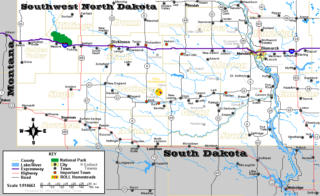
SOUTHWEST, NORTH DAKOTA MAP
Other NORTH DAKOTA Maps
North Dakota Towns of our Forefathers.
ADAMS County Towns
- Bucyrus
- Haynes
- Hettinger
- North Lemmon
- Reeder
BILLINGS County Towns
- Fairfield
- Fryburg
- Gortham
- Medora
BOWMAN County Towns
- Bowman
- Buffalo Springs
- Gascoyne
- Rhame
- Scranton
BURLEIGH County Towns
- Arena
- Baldwin
- Bismarck
- Driscoll
- Lincoln
- McKenzie
- Menoken
- Moffit
- Northwood Estates
- Regan
- Sterling
- Wilton
- Wing
DUNN County Towns
- Manning
- Marshall
- New Hradec
EMMONS County Towns
- Braddock
- Hazelton
- Hull
- Linton
- Strasburg
- Temvik
- Westfield
GOLDEN VALLEY County Towns
- Beach
- Golva
- Sentinel Butte
GRANT County Towns
- Brisbane
- Carson
- Elgin
- Fallon
- Heil
- Lark
- Leith
- New Leipzig
- Paradise
- Raleigh
- St. Gertrude
- St. Joseph
- Shields
HETTINGER County Towns
MERCER County Towns
- Beulah
- Golden Valley
- Hazen
- Zap
MORTON County Towns
- Almont
- Breien
- Cannon Ball
- Crown Butte rural community - This is an alternate name for St. Vincent rural community located NW1/4 Section 2-139-83, Sweet Briar Township. At one time, there was a store/pool hall/post office where the "Verine" club met, but the post office was closed in 1918. The hall building was sold and moved in 2002. The only existing buildings include the church and parish house. In 1996, a book about the history of St. Vincent and the surrounding families was published. Crown Butte is about 10 miles west of Mandan near I-94 and exit 147. From the most west exit of Mandan, go 6 miles west, 4 miles north to what they call 35th street, 4 miles west, and finally 1 mile south. That will take you to the Crown Butte church and cemetery. The FROHLICH family donated the land for the church. The church was named St. Margaret's Catholic Church but, after it burned down in 1933, it was rebuild and named St Vincent's. The directions indicate the way in which the roads are laid out. As the crow flies, it would, of course, be 10 miles west and 3 miles north.
It is located just north of the man-made Crown Butte lake. The main feature is Crown Butte Dam, a small fishing hole beside I-94. Crown Butte, the butte (hill/mound), is also a wildlife management area and is located in Township 140 North, Range 82W, Section 31, and is about 3 miles north of Interstate 95 and Crown Butte Lake. North of the freeway is referred to as the Crown Butte area and to the south is Sweet Briar country.
- Flasher
- Fort Rice
- Glen Ullin
- Hebron
- Huff
- Judson
- Mandan
- New Salem
- *Odense
- St. Anthony
- St. Vincent's rural community - see Crown Butte
- *Timmer
OLIVER County Towns
- Center
- Fort Clark
- Hannover
- Hensler
- *Otter Creek
- Price
- *Yucca
SLOPE County Towns
SOUIX County Towns
- Cannon Ball
- Fort Yates
- Selfridge
- Solen
STARK County Towns
 Walker Township Maps
  Steiner Township Maps